Why Us
Company Outlook
Mission
To revolutionize various industries through a sincere commit to the safe and strategic deployment of UAS.
Vision
To bring the future of UAS applications into focus by becoming the number one trusted provider of accurate, efficient, and compliant operations.
Core Values
Quality, Innovation, Reliability, Integrity, and Safety - without it, nothing else matters.
Our Commitment to Safety
Through our relationship with the Alberta Association for Safety Partnerships, our safety program has been recognized as COR compliant.


The Osprey Safety Program

- Comprehensive Company Operations Manual
- Safety Management System consisting of:
- Standard Operating Procedures
- Risk Assessment and Management Policies
- Airside Risk Assessment - Field Level Risk Control
- Environmental Protection Procedures
- Zero-Tolerance Drug and Alcohol Policy
- Emergency Response & Incident Reporting Procedures
- Frequent safety discussion relevant to UAV and Site-Specific operations
- Employee training, upgrading and participation incentive program
Current Training and Certifications
- Standard First Aid
- Transportation of Dangerous Goods
- Basic/Common Safety Orientation
- H2S Alive
- Fall Protection
- Confined Space Entry and Rescue
- WHMIS
- Elevated Work Platform
- Ground Disturbance
- Wilderness Awareness
- ...and more
Our Subject matter experts
Courtland Penk
Aerial Ultrasonics & Visual Inspection. Courtland comes from a strong lineage of aviation professionals. His grandfather served as a tail gunner for the Royal Canadian Air Force during the Second World War and his father made his living as a professional airline pilot for more than 40 years. Courtland recalls childhood memories of model aircraft flying and trips in the jump seats of Boeing 737s. At age 12, Courtland enrolled in the Royal Canadian Air Cadets where he began developing the professional foundation that would prove instrumental throughout the rest of his aviation career and into today. At age 21, he graduated from the Sault College of Technology with an Advanced Diploma in Aviation Technology, a Certificate in Airline Operations, and a Certificate in Airport Administration. Over the following years, Courtland held positions in flight instruction, fire detection, air ambulance, and corporate environments and furthered his knowledge of the industry culminating in his obtaining an Airline Transport Pilot License. After a slowdown in the economy, Courtland made the transition into the world of industrial inspection and quickly sought experience and certification realizing the endless comparisons between the two industries. He began with non-destructive examination, grew into visual inspection. Courtland has now worked from coast-to-coast across Canada, embracing roles as an NDE technician (with ultrasound being his primary method), CWB quality control inspector, and Authorized Pressure Vessel Inspector (API 510). His unique combination of skills and experience has had a profound impact on the way Osprey Integrity delivers drone inspection, constantly striving to set the bar higher.Jason Brownlee
Forestry & Precision Agriculture
Jason is a commercial pilot, turned environmental professional with 9 years’ experience as a consultant and regulatory professional with extensive project management experience in power transmission and pipeline project applications. He personally lays out about 200km of boundary/road and all associated profile plots for future timber cut blocks, per year.
He understands the need for accurate and concise data throughout the timber harvest cycle whether it be boundary/road layout, profile plots, stream classification, volume calculations, woody debris management and block recovery.
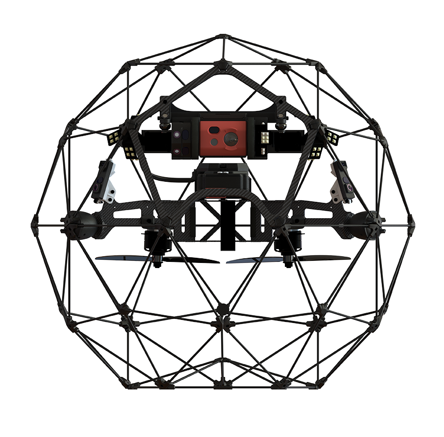
Forestry has traditionally relied on spot data from on the ground surveys which presents certain issues regarding accuracy, time, cost and safety. Unmanned aerial surveying combined with high resolution and multispectral cameras can provide quickly acquired data, metrics and knowledge previously considered impossible or impractical to attain through traditional survey methods.
Thanks to Jason’s varied experience with aviation and forestry operations, estimation and projection can be a thing of the past.
Cassidy Rankine
Advanced Data Analytics.Rankine Geospatial develops custom remote sensing solutions for commercial and industrial resource evaluation, monitoring, and management. Modern remote sensing technologies on satellite, airborne and robotic sensor systems are changing the landscape of how your business can measure large scale projects or processes with greater speed and efficiency. Dr. Cassidy Rankine is a remote sensing scientist and commercial application specialist with over 10 years experience solving business challenges using advanced spectral image analytics and custom GIS workflows using cutting-edge geospatial technologies.
Our Crews
We are proud to be working with some of the best people in the business!
Our Pilots
-
RPAS Advanced Operations Certified as per Canadian Aviation Regulations - Part IX
-
Graduates of Coastal Drone Co’s Advanced Operations Ground School Program
-
Hold Restricted Radio Operators Certificates – Aeronautical Band for direct communication with aircraft in the vicinity.
-
Further developed in accordance with our graduated UAS pilot program

Our Supporting Ground Staff
-
Ticketed Visual Inspectors – 3rd Party as Required (API, CWB, NB, NACE and more)
-
Forest Management & Environmental Experts
-
Earth Works - High Precision Survey Specialists
-
On Demand Agronomists
-
Qualified Visual Observers
We're Ready to Help!
Whether you have a question about our operations or a job that needs completing,
we have the answer!